2020 Virtual AIChE Annual Meeting
(744f) Soil Water Map Construction Using Microwave Sensor and Agro-Hydrological Model
Authors
In the context of obtaining soil moisture measurements, microwave remote sensing can be useful and has demonstrated the possibility of measuring the near-surface moisture quantitatively [1]. Microwave sensors mounted on central pivots provide a feasible approach to measure the soil water content of fields which have central pivots as irrigation implementers. The sensors measure the soil moisture content at different locations of the field as the central pivot rotates and provides the soil moisture information in the form of soil water content maps at the end of the pivotâs rotation cycle. There however exist three main challenges with this approach which reduces the usability of the soil water content maps for closed-loop irrigation. Firstly, it takes between two to three days for a central pivot to complete one rotation cycle which means that it also takes between two to three days to obtain a single water content map from the microwave sensors. This significant time delay in the soil moisture measurements means that very little or nothing can be done with the measurements when irrigation decisions are being made. Secondly, the current approach lacks a predictive capability in the sense that the sensors cannot provide soil moisture information of the field when the central pivot is stationary. Lastly, the current approach does not provide information in the root zone, knowledge of which is required for closed-loop irrigation.
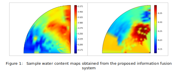
In this work, we propose the construction of frequently updated soil water content maps that can be used for irrigation decision making for fields equipped with microwave sensors mounted on central pivots. Firstly, we propose an agro-hydrological model that can accurately model a field equipped with a central pivot. The measurements obtained from the microwave sensors are then integrated with the field model and a state estimator, the Extended Kalman filter, in an information fusion system which will provide frequent estimates and predictions of soil water content in the form of soil water content maps for the surface of the field as well as the root zone.
We demonstrate the effectiveness of the proposed solution in providing frequently updated soil water content maps (Figure 1) using microwave sensor measurements obtained from the Alberta Irrigation Center in Lethbridge, Canada. We employ the Normalised Innovation Squared (NIS) test to demonstrate the consistency of our proposed approach. Finally, we validate the soil moisture estimates using a section of the microwave sensor measurements and show that our approach provides soil moisture estimates within reasonable error bounds from the actual measurements.
References
[1] P. K. Srivastava, D. Han, M. A. Rico-Ramirez, T. Islam, âSensitivity and uncertainty analysis of mesoscale model downscaled hydro-meteorological variables for discharge predictionâ Hydrol. Process., 28 (2013) pp. 4419-4432.
[2] âWater in a changing world,â The United Nations World Water Development Report 3, 2017.
[3] T. Sauer, P. Havlik, U. A. Schneider, E.Schmid, G. Kindermann, M. Obersteiner, âAgriculture and resource availability in a changing world: The role of irrigationâ Water Resourc. Res.,46 (2010).
